Landscape Photography Scotland:
Scotland is a prime destination for landscape photographers, offering diverse scenery including mountains, lochs, coastlines, and castles. Scotland is a landscape photographer’s dream, offering a diverse range of stunning locations and photographic opportunities. The country’s dramatic landscapes, rich history, and unique culture make it an ideal destination for capturing breathtaking images.
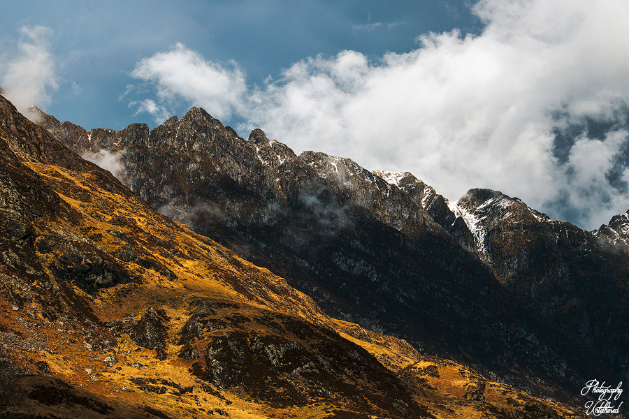
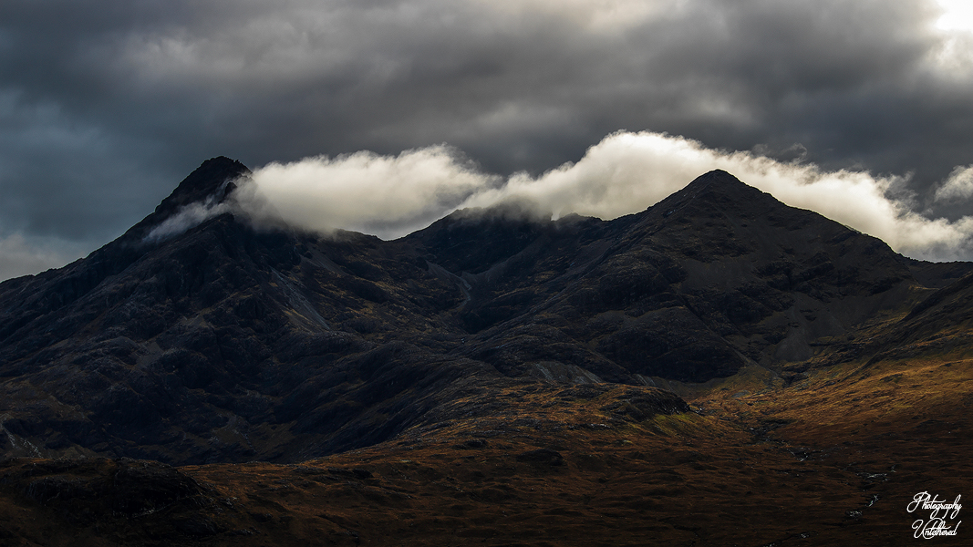
The optimal time for landscape photography in the Scottish Highlands varies based on your personal preferences. Spring (April-May) and autumn (late September-October) typically provide a great mix of enjoyable weather, vibrant colors, and good lighting. Summer (June-August) offers extended daylight hours, yet it also attracts larger crowds and midges. Winter (November-March) presents shorter days and the chance for stunning snowy scenes, but it necessitates careful planning due to limited daylight and possible road closures. The weather in the Scottish Highlands is famously unpredictable, making flexibility crucial. Be ready for swiftly changing conditions like rain, strong winds, hail and snow. Regularly check weather forecasts, but stay prepared to adjust your plans as needed. Layered clothing and waterproof gear are vital.
Ben Nevis Photography:
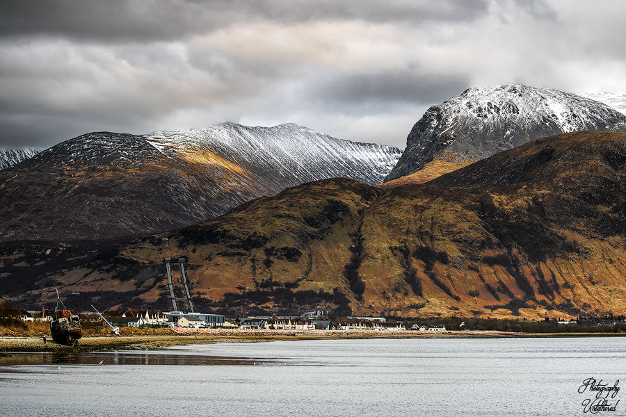
At the village of Corpach, on the banks of Loch Linnhe, the majestic summit of Ben Nevis rises above its neighbours like a guardian of the landscape. Fresh winter snow blankets its peak in pristine white, while warmer months reveal its rugged brown slopes. Aerial views capture the essence of this remarkable mountain, evoking images of both cold dough and a perfectly baked loaf. Yet, from the ground, Britain’s highest mountain often plays a game of hide and seek, frequently cloaked in ethereal mist. Its unique location and towering height, standing at 1,345 metres beside the shimmering sea loch, give rise to a cloudy microclimate rife with sudden storms.
The name Ben Nevis, believed to stem from the Gaelic ‘beinn nèamh-bhathais,’ reflects its lofty spirit as the ‘mountain with its head in the clouds,’ while the alternative ‘beinn nibheis’ warns of its fierce nature. Both names serve as a reminder of the respect and preparedness required to embrace the challenges that this incredible mountain presents. By the time I arrived at this location, I had lost the best of the light, but it still looked decent. The wind was breezy and very cold, which is why there was a lack of reflection. April fools day 2024.
Dùn na Cuaiche, Photography:
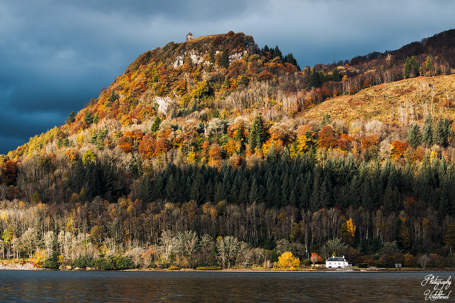
The Dùn na Cuaiche Watchtower is an iconic landmark for those journeying down the A83 through Argyle. Perched majestically at 248 meters above the town, it provides stunning panoramic views of the town and the nearby Loch Fyne. On clear days, the surrounding mountains and forests come into view, showcasing nature’s beauty. Built in 1756 as a folly by the land and castle’s owners, its purpose was purely decorative.
Strategically positioned, it rests not at the highest point but on the steep edge of the hill, allowing it to be beautifully silhouetted against the sky when seen from the town or castle. Remarkably, despite being struck by lightning multiple times, it stands resilient and proud after all these years. This was taken at the end of October 2023. My girlfriend at the time was sitting in the car and missed the magical autumn light show. Luckily for her, however, she was given a beautiful framed copy to hang on the wall.
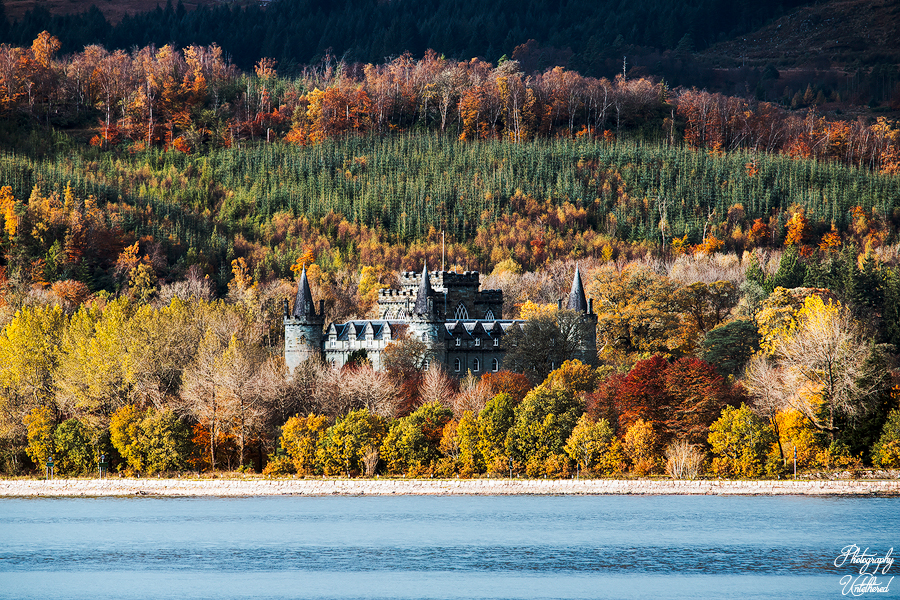
Inveraray Castle Photography:
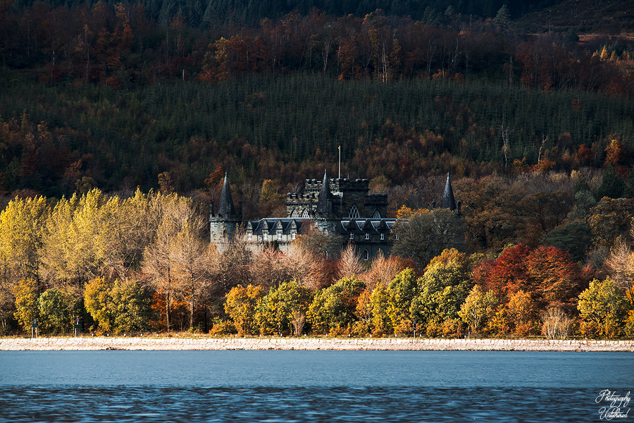
The ancient Royal Burgh of Inveraray, located 60 miles northwest of Glasgow by Loch Fyne, is set against a backdrop of breathtaking natural beauty. The rugged highland landscape creates a stunning environment for the tranquil tidal Loch, where the present castle stands proudly, built between 1746 and 1780.
Inveraray Castle, the ancestral home of the Dukes of Argyll and the Chiefs of the Clan Campbell, has been the residence of the Campbell family since the early 15th century. Designed by Roger Morris and decorated by Robert Mylne, the castle features a fairytale façade that complements its equally enchanting interior. The beautiful late October light in 2023 was captured handheld at F11, with a shutter speed of 1/15 of a second, and ISO 100 for both images.
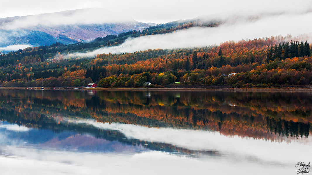
Loch Eil Photography:
Loch Eil is a stunning sea loch nestled in the picturesque region of Lochaber, Scotland, where its waters flow into the expansive Loch Linnhe, just a stone’s throw from the town of Fort William. Captured in the golden hues of October 2021, this photograph beautifully showcases the vibrant red boathouse that stands proudly along the shore, imbued with a Nordic charm that adds a striking contrast to the dark conifers behind and reflected in the loch. The scene evokes a sense of quiet solitude, inviting viewers to immerse themselves in the beauty of this magical landscape.
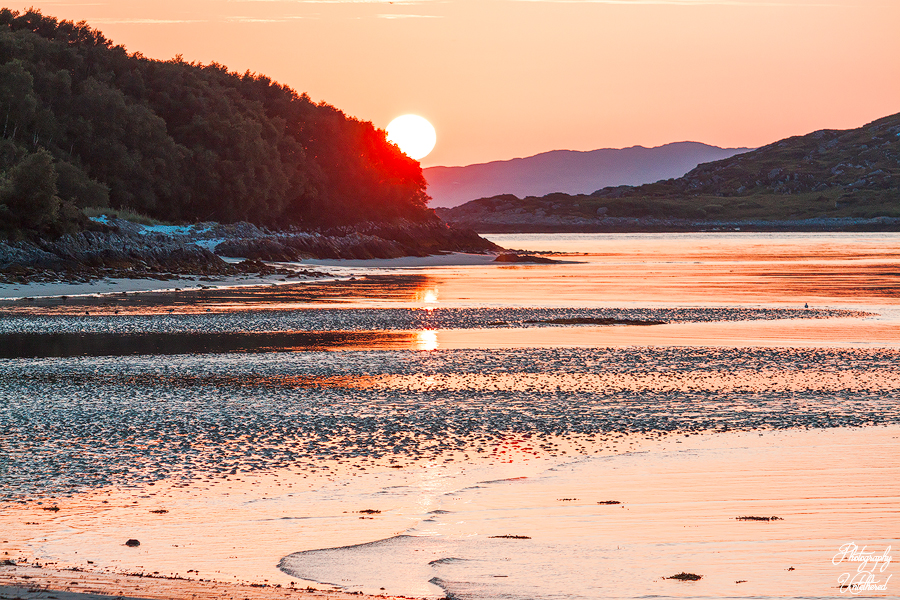
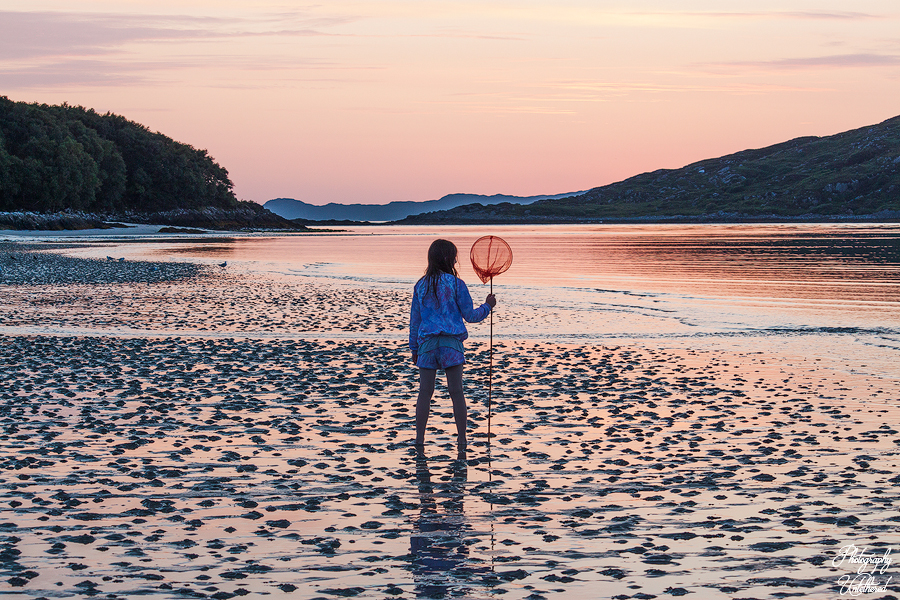
Morar Beach Photography:
Morar Beach, located in the Scottish Highlands, is renowned for its stunning natural beauty, characterized by its silver sands and turquoise waters. This beach is part of a series of small beaches that stretch along the coastline from Arisaig to Morar, making it a popular destination for visitors seeking picturesque landscapes and tranquil settings. Morar Beach was chosen for its visual appeal and peaceful atmosphere for several scenes in the 1983 movie Local Hero. The images above were captured in late July 2021. The sunset was breathtaking, and my daughter, with her fishing net, created a captivating scene.
Aonach Eagach Photography:
The Aonach Eagach is a renowned ridge in Glencoe, Scotland, famous for being one of the British mainland’s most challenging and exhilarating scrambles. It stretches approximately 10 kilometers and connects two Munros: Meall Dearg (953 meters) and Sgorr nam Fiannaidh (967 meters). Its narrowness, steep drops, and technical scrambling sections characterise the ridge, making it a favorite among experienced hillwalkers and climbers.
I recall traversing Aonach Eagach ridge shortly after my son Jack was born in 2001. A seasoned friend had advised me against going solo, and consequently, anxiety kept me awake at the Clachaig Inn the night before. Nevertheless, I found myself on the ridge by 7:30 am, enjoying an incredible experience with the entire ridge to myself. I wonder if that could still happen today.
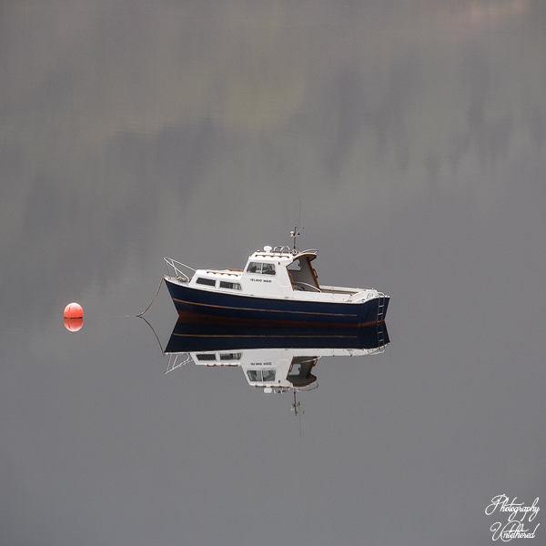
Loch Long Photography:
Loch Long is a picturesque sea loch located in Argyll and Bute, Scotland. It extends approximately 20 miles (30 kilometres) from its mouth at the Firth of Clyde to the village of Arrochar at its northern end. The loch is characterised by its long, narrow shape, resembling a fjord, with widths ranging from 1 to 2 miles (2 to 3 kilometres) and depths reaching up to 30 metres.
The name “Loch Long” translates from Gaelic as “Ship Lake,” reflecting its historical importance as a navigable waterway. In 1263, Viking raiders utilised this loch to access inland settlements by dragging their longships overland to Tarbet before launching attacks on unprotected areas around Loch Lomond. This historical context adds depth to the cultural significance of the loch and its surroundings.
The image of the “Island Maid” boat showcased above was captured from a window in my room at the Arrochar Hotel. I admit it’s a bit of a lazy shot, but considering it was taken handheld at 183mm with an aperture of F8 and a shutter speed of 1/20 sec, I think it turned out quite well. 🙂
Sgùrr nan Gillean Photography:
Sgùrr nan Gillean is a prominent peak on the Isle of Skye in Scotland, recognised as one of the most iconic mountains in the Cuillin range. Standing at an elevation of 964 meters (3,162 feet), it may not be the highest peak in the Cuillin, but it is often considered one of the most beautiful and challenging to climb. The mountain has a striking pyramidal shape, making it a popular subject for photography and a favourite destination for hikers and climbers.
The terrain around Sgùrr nan Gillean is rugged and demanding. The most common route to the summit is the Southeast Ridge, often called the “Tourist Route.” This path begins at Sligachan, where hikers cross a bridge over the Allt Dearg Beag stream before ascending into Coire Riabhach. The route involves some scrambling, especially on the ridge itself, which can be exposed and requires careful navigation.
Sgùrr na Lapaich Photography:
Sgùrr na Lapaich in Glen Affric is a prominent mountain in the Northwest Highlands of Scotland, distinct from the higher Sgùrr na Lapaich north of Loch Mullardoch. Standing at 1,036 meters (3,399 feet), it is located on the north side of Loch Affric and is recognised as a “Munro Top” of Mam Sodhail, meaning it is a subsidiary peak of a higher Munro.
Despite its demotion from the original Munro list in 1923, many still argue for its reinstatement due to its significant height, character, and the considerable separation from neighbouring peaks, often taking over an hour to traverse from Mam Sodhail .
The mountain offers challenging and rewarding ascent routes, often approached from the head of Glen Affric road, near Chisholme Bridge. A well-constructed path leads up through trees to Gleann nam Fiadh, eventually joining a track before venturing towards the Affric Munros.
Hikers often follow a stalker’s path past Affric Lodge and Am Meallan to Gleann nam Fiadh, then proceed across boggy terrain to the ridge of Sgùrr na Lapaich. The ascent up the southeast shoulder involves a faint path that becomes clearer higher up, sometimes requiring a scramble to reach the summit.
The views from the summit are extensive, encompassing Loch Affric, Mam Sodhail, Carn Eighe, and the surrounding rugged landscape. Sgùrr na Lapaich is frequently included in longer circuits, such as the “Affric Munros” horseshoe, which can include Carn Eighe and Mam Sodhail, offering a substantial day out for experienced hikers.
The area is known for its wild beauty, with deep corries, lochans, and diverse terrain, making it a popular destination for hillwalkers. Captured Handheld on an amazing October day in 2021, ISO 200 | F11 | 1/60 sec
Minginish Peninsula and Loch Bracadale | Isle of Skye
From the iconic Dun Beag Broch on the Isle of Skye, you are greeted with breathtaking views of the Minginish Peninsula, which showcases its dramatic coastline and rugged landscapes. On clear days, the distant Cuillin mountains stand majestically in the background, creating a stunning panorama. This remarkable vista captures the essence of the west coast of Skye, overlooking Loch Bracadale and inviting all to revel in its natural beauty. This photograph was taken from the Dun Beag Broch car park.
Photo Info: Handheld October 2023, ISO 100 | F11 | 1/40 sec
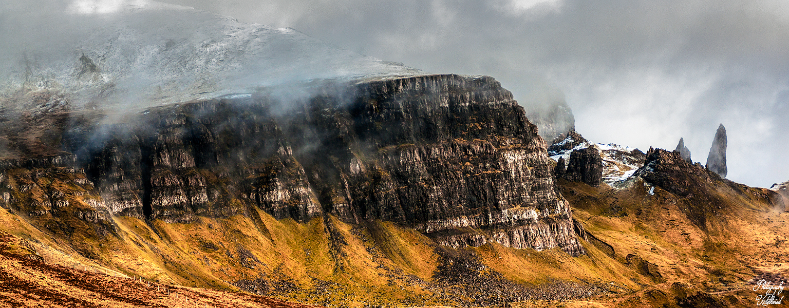
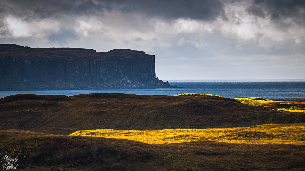
“The Storr”: Trotternish Peninsula | Isle of Skye
The Storr, known in Gaelic as An Stòr, is a prominent geological feature located on the Trotternish Peninsula of the Isle of Skye, Scotland. It is the highest point of the Trotternish Ridge, reaching an elevation of 719 meters (2,358 feet). The name “Storr” likely derives from the Gaelic word Stór, meaning a broken tooth or cliff, aptly describing its dramatic appearance. This area is renowned for its unique landscape, characterised by high cliffs, terraces, pinnacles, and unusual rock structures, making it a masterpiece of natural architecture. The most famous of these formations is the Old Man of Storr, a 55-meter (180-foot) high basalt pinnacle that stands as a remnant of a 2,800-million-year-old volcanic plug.
The Trotternish Ridge itself was formed approximately 60 million years ago by a massive landslip. Hot volcanic lava flowed onto weaker sedimentary Jurassic rock, causing the latter to collapse and create the undulating cliff faces along the eastern coastline of Trotternish. Over millennia, the Storr has been shaped by wind, rain, ice, and frost, resulting in chasmic gullies and its distinctive weathered basalt rock formations. The Storr dominates the island’s north-eastern landscape and is visible for miles, both from travellers heading north and from the Scottish mainland.
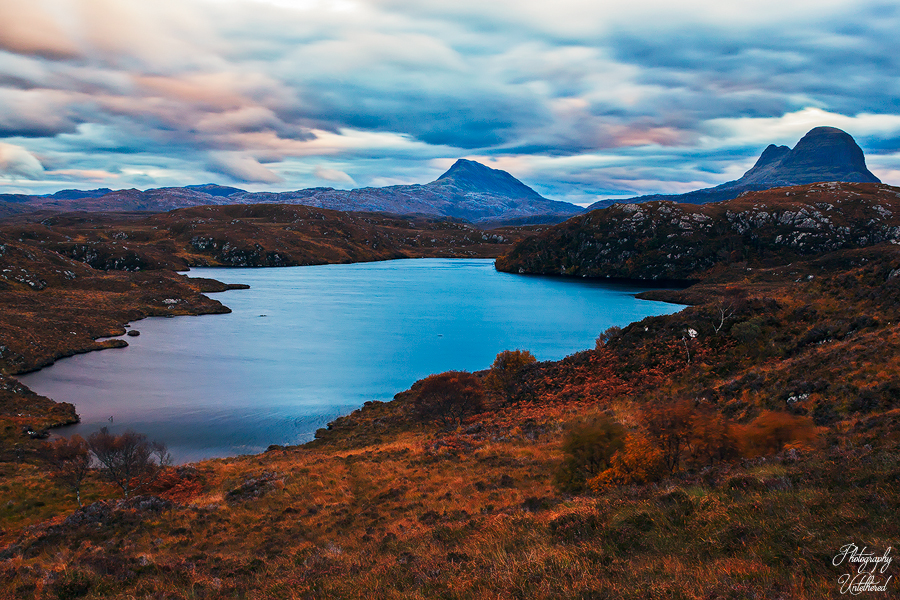
Loch Bad na Goibhre & Canisp & Suilven:
Loch Bad na Goibhre is a freshwater loch located in Sutherland, Scotland. It is situated to the east of Lochinver. and is part of the broader Assynt region, an area known for its wild and beautiful landscapes, including mountains like Canisp and Suilven. Canisp and Suilven are two prominent mountains located in the Assynt region of the Scottish Highlands, known for their distinctive profiles and challenging terrain. Canisp, with a height of 847 meters (2,779 ft), qualifies as a Corbett and Marilyn hill. In contrast, Suilven, though lower at 731 meters, is often considered more visually arresting due to its unique shape. Both mountains are situated in the Glencanisp Forest, a vast wilderness characterised by rock and water.
Click for Posts on Scotland
The website is self-funded, and my work is free. All profits from the site’s product links go to SightSavers; if you have enjoyed any aspect of this site, please consider a giving a donation here. No one should go blind from avoidable causes. How many people’s sight will you help us save today?
Fragmented Memory 🙂